


Étape 2 GTMC mont Aigoual

lorenzot54
Gebruiker

Lengte
42 km

Max. hoogte
1561 m

Positief hoogteverschil
1605 m
Km-Effort
60 km

Min. hoogte
464 m

Negatief hoogteverschil
525 m
Boucle
Neen
Datum van aanmaak :
2020-07-07 06:24:00.0
Laatste wijziging :
2020-07-07 13:34:57.509
3h58
Moeilijkheid : Onbekend

Gratisgps-wandelapplicatie
 SityTrail
IGN / Geografische instituten
SityTrail Plus
De wereld gaat voor u open
Over ons
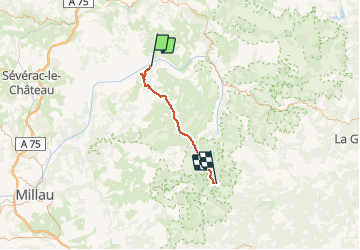
Tocht Mountainbike van 42 km beschikbaar op Occitanië, Lozère, Gorges du Tarn Causses. Deze tocht wordt voorgesteld door lorenzot54.
Plaatsbepaling
Land:
France
Regio :
Occitanië
Departement/Provincie :
Lozère
Gemeente :
Gorges du Tarn Causses
Locatie:
Sainte-Enimie
Vertrek:(Dec)
Vertrek:(UTM)
531786 ; 4911089 (31T) N.
Opmerkingen